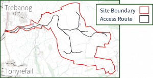
The proposed wind farm would be located on the summit and upper slopes of Mynydd y Glyn to the south of the Rhondda River. As currently defined, the site extends to approximately 208 hectares consisting of upland habitat, mostly improved and semi-improved grassland that has been used for agricultural grazing.
The grid connection to Upper Boat would comprise of approximately 1.5km of new line on wooden poles and a further 7.5km underground via ducting in the highway network.
Access to the wind farm site would be from a newly proposed construction vehicle access on the A4233 Trebanog Road. The proposed site access is located approximately 1.2km north-east of the A4233/A4119 roundabout. Relevant surveys were undertaken to inform the design specification of the proposed access, which includes a new right turn lane on the A4233 so that traffic turning right into the site does not block main road traffic.
If approved and once the proposed wind farm is constructed, the proposed access from the A4233 will be retained for routine maintenance vehicles that will visit the site on an infrequent basis. The access would be gated at all other times when not in use by the occasional routine maintenance vehicle.